Atajo volcán Pacaya
Location: San Vicente Pacaya
GPS coordinates: 14.39526,-90.61286
Latest update: November 24, 2025 10:22
Castillo de Dorión
10 km
Finca el barretal
5.6 km
Cerro Chiquito
1.9 km
Cerro La Montaña (bolkan)
6.9 km
Cerro La Mariposa
8 km
Cerro Mal Paso (bolkan)
8.6 km
Cerro Grande (bolkan sa Guatemala, Departamento de Guatemala)
3.4 km
Cerro Chino (bolkan sa Guatemala, Departamento de Escuintla)
1.5 km
Cerro Limón (bolkan)
6.2 km
Automariscos
6.2 km
Pacaya
1 km
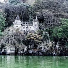
Château defay
10.9 km
Antenas camimo al volcán Pacaya
348 m
Pacaya Pizza
1 km
Mayan Golf Club
11.3 km
Irtra de Amatitlan
9.2 km
Pacaya
1.6 km
Pacaya
748 m
La Ceiba
9.3 km
Mirador Laguna de Calderas
1 km
Primer mirador Cerro chino
275 m
Mirador 2 cerro chino
591 m
Mirador 3 cerro chino
745 m
Scenic viewpoint
11 km
Scenic viewpoint
10.4 km
Scenic viewpoint
10.4 km
Scenic viewpoint
10.2 km
Cascada Fuentes del Pacaya
6.3 kmReviews
Visited this place? Tap the stars to rate it and share your experience / photos with the community! Try now! You can cancel it anytime.
Discover hidden gems everywhere you go!
From secret cafés to breathtaking viewpoints, skip the crowded tourist spots and find places that match your style. Our app makes it easy with voice search, smart filtering, route optimization, and insider tips from travelers worldwide. Download now for the complete mobile experience.

A unique approach to discovering new places❞
— Le Figaro
All the places worth exploring❞
— France Info
A tailor-made excursion in just a few clicks❞
— 20 Minutes