Carrickalinga Beach
Location: Carrickalinga
Location: The District Council of Yankalilla
GPS coordinates: -35.42447,138.32109
Latest update: November 23, 2025 14:39
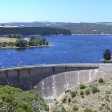
Myponga Reservoir
11.5 km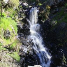
Ingalalla Waterfalls
12 km
Myponga Conservation Park
10.8 km
Dodd Beach
1.2 km
Anacotilla Sanctuary
12.2 km
Garnett Kelly Park
5.4 km
Baker Nob
11.3 km
Bungala Park
2.7 km
Mount Hayfield
11 km
Moon Hill
11.6 km
Heatherdale Hill
11.9 km
Normanville Beach
1.6 km
Ingalalla Falls
12 km
Normanville Beach
2.7 km
Wirrina Golf Course
11.1 km
Normanville Beach
4 km
Work of art, sculpture
3.6 km
Hobart Memorial Lookout
7.6 km
Scenic viewpoint
9.2 km
Scenic viewpoint
1.6 km
Carrickalinga Beach
1.2 km
Forest Walk Lookout
12.1 km
Homestead Ruin Lookout
12.3 km
Scenic viewpoint
7.6 km
Torrens Vale Lookout
10.5 km
Ruins
12.3 km
Ruins
6.8 km
Commemorative plaque, memorial
4.4 kmReviews
Visited this place? Tap the stars to rate it and share your experience / photos with the community! Try now! You can cancel it anytime.
Discover hidden gems everywhere you go!
From secret cafés to breathtaking viewpoints, skip the crowded tourist spots and find places that match your style. Our app makes it easy with voice search, smart filtering, route optimization, and insider tips from travelers worldwide. Download now for the complete mobile experience.

A unique approach to discovering new places❞
— Le Figaro
All the places worth exploring❞
— France Info
A tailor-made excursion in just a few clicks❞
— 20 Minutes