Chittering Road Board Office, heritage listed building in Chittering, Western Australia
Location: Shire of Chittering
GPS coordinates: -31.41621,116.09362
Latest update: November 20, 2025 09:35

Paruna Sanctuary
30.4 km
Drummond Nature Reserve
31.7 km
Moondyne Nature Reserve
20.6 km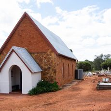
Saint Philip Church, Culham Western Australia
32.9 km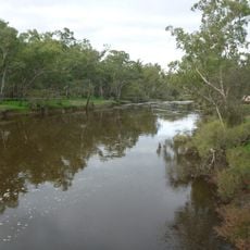
Cobbler Pool
26.6 km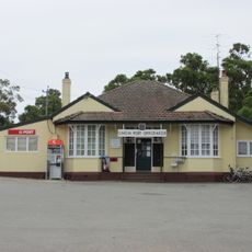
Gingin Post Office
19.6 km
Bindoon Spring Nature Reserve
24.4 km
Wally Jones Park
28.9 km
Muchea Trig Hill
25 km
Spoonbill Park
1.9 km
Aquila Park
2.5 km
Belle Caddy Park
1.9 km
Molecap Hill
18.6 km
St Luke's (Anglican) Church Rectory
19.6 km
Boomer Hill
26.7 km
Moondah Homestead
16.7 km
St Luke's Anglican Church, Cemetery and Belfry
19.5 km
Catholic Agricultural College, Bindoon
13.8 km
Dewar's House
19.1 km
Enderslea
5.9 km
Chittering Park Homestead
22.4 km
Chequers Golf Club
25.8 km
Perth's Outback Splash
29.3 km
Paruna Sanctuary
31.5 km
Mural, Work of art
28.3 km
Walyunga Lookout
31.8 km
Scenic viewpoint
7.5 km
Afdraai railway road
11.7 kmReviews
Visited this place? Tap the stars to rate it and share your experience / photos with the community! Try now! You can cancel it anytime.
Discover hidden gems everywhere you go!
From secret cafés to breathtaking viewpoints, skip the crowded tourist spots and find places that match your style. Our app makes it easy with voice search, smart filtering, route optimization, and insider tips from travelers worldwide. Download now for the complete mobile experience.

A unique approach to discovering new places❞
— Le Figaro
All the places worth exploring❞
— France Info
A tailor-made excursion in just a few clicks❞
— 20 Minutes