Black Rock, town in South Australia
Location: The District Council of Orroroo Carrieton
GPS coordinates: -32.82985,138.68923
Latest update: November 25, 2025 09:58

Steamtown Heritage Rail Centre
20.7 km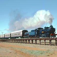
Steamtown, Peterborough Railway Preservation Society Inc.
21.1 km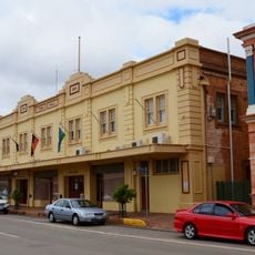
Peterborough Town Hall
21.2 km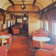
Steamtown Heritage Rail Centre
20.7 km
Peterborough Motorcycle & Antique Museum
21 km
Mount Williams
22.7 km
Mount Swan
22.3 km
Mount Robert
20.8 km
Mount Charlie
16.3 km
Barra Hill
14.2 km
Black Rock
14.8 km
Depot Hill
11.5 km
Champion Hill
17.4 km
Granite Top
14 km
Milkia Hill
13.4 km
Hogshead Hill
14 km
Pekina Hill
16.4 km
Magnetic Hill
7.2 km
Tarcowie Golf Course
20.9 km
Peterborough Golf Club
20.2 km
Dragon's Rest
20 km
Bald Hill
12.3 km
Scenic viewpoint
19.7 km
Tank Hill Lookout
12.9 km
Big Tree view point
13.7 km
Goyders Line
12 km
Tarcowie 1873-1973
20.9 km
Cannon
12.7 kmReviews
Visited this place? Tap the stars to rate it and share your experience / photos with the community! Try now! You can cancel it anytime.
Discover hidden gems everywhere you go!
From secret cafés to breathtaking viewpoints, skip the crowded tourist spots and find places that match your style. Our app makes it easy with voice search, smart filtering, route optimization, and insider tips from travelers worldwide. Download now for the complete mobile experience.

A unique approach to discovering new places❞
— Le Figaro
All the places worth exploring❞
— France Info
A tailor-made excursion in just a few clicks❞
— 20 Minutes