Macleod Trail Cultural Landscape, cultural landscape in Okotoks, Alberta, Canada
Location: Okotoks
Address: 33 Mountain Street
GPS coordinates: 50.72718,-113.97809
Latest update: November 23, 2025 12:31
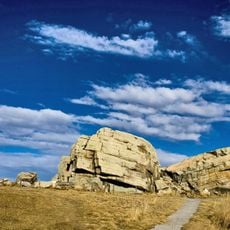
Okotoks Erratic
7.3 km
Davisburg Church
11.2 km
Okotoks United Church
275 m
Okotoks Post Office
771 m
Stockton Block (Okotoks Town Hall)
344 m
Old Post Office Building
18 km
Seton Library
17.1 km
Garrett Residence
17.9 km
F. M. Ranch Archaeological Site
17.1 km
St. Joseph's (Dunbow) Industrial School
16 km
Old Lineham House
136 m
Mahon House
258 m
Stone Finder Observatory
6.8 km
W.O. Mitchell House
17.9 km
WizGolf
1.8 km
Sirocco Golf Club
15.4 km
D'Arcy Ranch Golf Club
1.6 km
Cottonwood Golf & Country Club
16.2 km
Blue Devil Golf Club
17.6 km
Highwood Golf And Country Club
17 km
Carnmoney Golf & Country Club
11.9 km
Crystal Ridge Golf Club
2.5 km
Saskatoon Farm
8.4 km
Saskatoon Farm
8.6 km
Okotoks Art Gallery
798 m
Purple Dog
17.2 km
Scenic viewpoint
16.8 km
Scenic viewpoint
1.2 kmReviews
Visited this place? Tap the stars to rate it and share your experience / photos with the community! Try now! You can cancel it anytime.
Discover hidden gems everywhere you go!
From secret cafés to breathtaking viewpoints, skip the crowded tourist spots and find places that match your style. Our app makes it easy with voice search, smart filtering, route optimization, and insider tips from travelers worldwide. Download now for the complete mobile experience.

A unique approach to discovering new places❞
— Le Figaro
All the places worth exploring❞
— France Info
A tailor-made excursion in just a few clicks❞
— 20 Minutes