Wegkreuz, mitte 18. Jh.; am westlichen Ortsrand
Location: Prien am Chiemsee
Address: Priener Straße 27
GPS coordinates: 47.84989,12.32208
Latest update: November 11, 2025 23:41
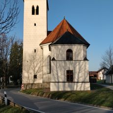
St. Salvator
840 m
Pinswang 15
875 m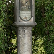
Bildstock
80 m
Hofkapelle Latschenweg
603 m
Elektrizitätswerk Prien
536 m
Geschnitzte Haustür
1 km
Cultural heritage D-1-8139-0004 in Prien am Chiemsee
727 m
Elektrizitätswerk Bachweg 4 in Prien am Chiemsee
541 m
Marienfigur
405 m
Geschnitzte Tür
241 m
Kapelle St. Anna
1 km
Bauernhaus
747 m
Bauernhaus
931 m
Bildstock
697 m
Kapelle
695 m
Field monument in Prien a.Chiemsee (D-1-8139-0252)
611 m
Cultural heritage D-1-8139-0199 in Rimsting
835 m
Wayside cross
979 m
Wayside cross
950 m
Burgstall Urschalling
697 m
Wayside cross
919 m
Wayside cross, Christianity
428 m
Wayside cross
2 m
Kreuzwegsäule
855 m
Wayside shrine
815 m
Kreuzwegsäule
877 m
Kreuzwegsäule
912 m
Kreuzwegsäule
969 mReviews
Visited this place? Tap the stars to rate it and share your experience / photos with the community! Try now! You can cancel it anytime.
Discover hidden gems everywhere you go!
From secret cafés to breathtaking viewpoints, skip the crowded tourist spots and find places that match your style. Our app makes it easy with voice search, smart filtering, route optimization, and insider tips from travelers worldwide. Download now for the complete mobile experience.

A unique approach to discovering new places❞
— Le Figaro
All the places worth exploring❞
— France Info
A tailor-made excursion in just a few clicks❞
— 20 Minutes