Bauernhaus, house in Anger, Bavaria, Germany
Location: Anger
Address: Stoißberg 16
GPS coordinates: 47.80686,12.83877
Latest update: November 20, 2025 19:57
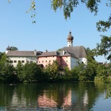
Höglwörth Abbey
1 km
Wegkapelle
893 m
Brunnen Stockham 6 in Anger (Berchtesgadener Land)
768 m
Nebengebäude Zellberg 11 in Anger (Berchtesgadener Land)
715 m
Zuhaus
835 m
Türgewände
870 m
Schornermühle
750 m
Türstock und Haustür
809 m
Cultural heritage D-1-8143-0208 in Anger (Berchtesgadener Land)
506 m
Bauernhaus
766 m
Bauernhaus
311 m
Klostermauer Höglwörther Straße 27 in Anger (Berchtesgadener Land)
1 km
Figuren
871 m
Klosterökonomie Höglwörther Straße 27 in Anger (Berchtesgadener Land)
1 km
Wohnhaus
850 m
Obermühle
720 m
Bauernhaus
768 m
Wassermühle Zellberg 10; Zellberg 11 in Anger
769 m
Türstock und Haustür
819 m
Rothenauhof, Bauernhaus
839 m
Wohnhaus
777 m
Bauernhaus
763 m
Weberhäusl
374 m
Bauernhaus
798 m
Wayside cross
453 m
Wayside cross
768 m
Wayside cross
228 m
Wayside cross
413 mReviews
Visited this place? Tap the stars to rate it and share your experience / photos with the community! Try now! You can cancel it anytime.
Discover hidden gems everywhere you go!
From secret cafés to breathtaking viewpoints, skip the crowded tourist spots and find places that match your style. Our app makes it easy with voice search, smart filtering, route optimization, and insider tips from travelers worldwide. Download now for the complete mobile experience.

A unique approach to discovering new places❞
— Le Figaro
All the places worth exploring❞
— France Info
A tailor-made excursion in just a few clicks❞
— 20 Minutes