
Bildstockschaft, granitpfeiler mit abgefasten Kanten, wohl 18. Jahrhundert
Location: Störnstein
Address: In Ernsthof
GPS coordinates: 49.75262,12.19186
Latest update: November 12, 2025 06:14
Bezirksklinikum Wöllershof
835 m
Lager Wöllershof 1 in Störnstein
856 m
Bildstock
244 m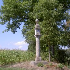
Bildstock im G'fries
298 m
Gedenkkreuz
901 m
Torhaus Wöllershof 1 in Störnstein
833 m
Gutshof
863 m
Küche Wöllershof 1 in Störnstein
851 m
Remise Wöllershof 4 in Störnstein
896 m
Büro- und Verwaltungsgebäude Wöllershof 1 in Störnstein
868 m
Taubenhaus Wöllershof 4 in Störnstein
892 m
Hofkapelle Wöllershof 4 in Störnstein
842 m
Festsaal Wöllershof 1 in Störnstein
859 m
Lagerhalle Wöllershof 4 in Störnstein
920 m
Dorfbenennungsstein
921 m
Bildstock
1 km
Wohnhaus Wöllershof 1 in Störnstein
820 m
Bildstock
975 m
Hofmauer Wöllershof 4 in Störnstein
844 m
Cultural heritage D-3-6239-0034 in Störnstein
835 m
Wayside shrine
981 m
Wayside cross
907 m
Wayside shrine
238 m
Wayside shrine
2 m
Wayside shrine
863 m
Wayside cross
297 m
Wayside shrine, Christianity, Catholic church building
818 m
Catholic church building, wayside shrine, Christianity
792 mReviews
Visited this place? Tap the stars to rate it and share your experience / photos with the community! Try now! You can cancel it anytime.
Discover hidden gems everywhere you go!
From secret cafés to breathtaking viewpoints, skip the crowded tourist spots and find places that match your style. Our app makes it easy with voice search, smart filtering, route optimization, and insider tips from travelers worldwide. Download now for the complete mobile experience.

A unique approach to discovering new places❞
— Le Figaro
All the places worth exploring❞
— France Info
A tailor-made excursion in just a few clicks❞
— 20 Minutes