LSG-Gommershovener Busch, protected area in Germany
Location: Bedburg
Inception: 1988
GPS coordinates: 51.02421,6.63538
Latest update: November 14, 2025 12:27
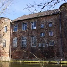
Burg Geretzhoven
2.6 km
Gut Nanderath
1.6 km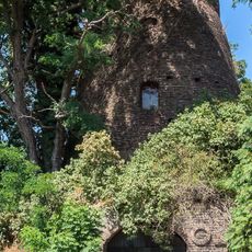
Rath - Rather Mühle
2.3 km
LSG-Totengraben
2.7 km
LSG-Neurath-Ost
2.7 km
LSG-Guerather Hoehe
1.4 km
LSG-Gut Gommershoven
737 m
LSG-Zenshof und Schopenhof
1.8 km
LSG-Rather Muehle
2.3 km
LSG-Neurath Suedost
1.5 km
Kloster St. Antonius, Bedburg (Erft-)Frauweiler
2.8 km
Wayside cross
1.9 km
Gedenkstein Gut Nanderath
2.6 km
Wayside cross
2.1 km
Wayside cross
2 km
Wayside shrine
2.3 km
Wayside cross
1.8 km
Ehrenmal
2 km
Wayside cross
2 km
Gedenkstein Umsiedlung Frauweiler Garsdorf 1965
1.9 km
Wayside shrine
2.4 km
Erinnerungsstein Frauweiler
2.6 km
Gedenkkreuz Klosterkirche St. Luzia Frauweiler
2.6 km
Gedenkstein Cornelius Klauth
2.3 km
Gedenktafel zur Erinnerung an Garsdorf
2.6 km
Memorial, memorial stone
1.9 km
Memorial stone, memorial
1.9 km
Memorial stone, memorial
1.9 kmReviews
Visited this place? Tap the stars to rate it and share your experience / photos with the community! Try now! You can cancel it anytime.
Discover hidden gems everywhere you go!
From secret cafés to breathtaking viewpoints, skip the crowded tourist spots and find places that match your style. Our app makes it easy with voice search, smart filtering, route optimization, and insider tips from travelers worldwide. Download now for the complete mobile experience.

A unique approach to discovering new places❞
— Le Figaro
All the places worth exploring❞
— France Info
A tailor-made excursion in just a few clicks❞
— 20 Minutes