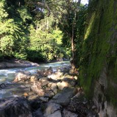
Nam Tok Ton Phet, Wasserfall in Thailand
Location: Ranong province
Elevation above the sea: 296 m
GPS coordinates: 9.72306,98.63361
Latest update: November 20, 2025 11:20
Namtok Ngao National Park
14.8 km
Wat Thamma Wuttharam
15.7 km
Wat Ko Phayam
23.6 km
Wat Nok Ngang
6.3 km
Wat Pathum Thararam
14.4 km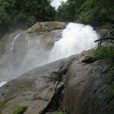
Nam Tok Heo Lom
5.3 km
Nam Tok Narai
14.5 km
Nam Tok Khlong Rang
21.2 km
Nam Tok Ton Thong
8.1 km
Nam Tok Ngao
14.5 km
Ko Lao Beach
23.1 km
Hat Bang Ben
22.4 km
Lantalay Crocadile Farm
15.9 km
Ao mook
23.3 km
Wat Ban Ngao
14.9 km
Had Ao Siad
21.9 km
Kam Beach
23.3 km
Ko Mu Beach
14.2 km
Ao Khoei
20.5 km
Muelle
23.4 km
Scenic viewpoint
23 km
Scenic viewpoint
15.1 km
Phu Khao Ya
16.2 km
Castle
14.9 km
Wayside shrine
19.1 km
Nga Ngoi Waterfall (upper)
14.5 km
Nga Ngoi Waterfall (down)
14.7 km
Waterfall
15.2 kmReviews
Visited this place? Tap the stars to rate it and share your experience / photos with the community! Try now! You can cancel it anytime.
Discover hidden gems everywhere you go!
From secret cafés to breathtaking viewpoints, skip the crowded tourist spots and find places that match your style. Our app makes it easy with voice search, smart filtering, route optimization, and insider tips from travelers worldwide. Download now for the complete mobile experience.

A unique approach to discovering new places❞
— Le Figaro
All the places worth exploring❞
— France Info
A tailor-made excursion in just a few clicks❞
— 20 Minutes