, ehemaliges Bauernhaus, Hakenanlage mit Blockbau-Obergeschoss, 17. /18. Jahrhundert
Location: Palling
Address: Schreckenbach 9
GPS coordinates: 48.03039,12.64433
Latest update: November 8, 2025 18:50

Kolmandelfeld, Palling
894 m
Kornspeicher Lindenstraße 10 in Palling
1.2 km
Cultural heritage D-1-7941-0254 in Palling
1.2 km
Stadel Waltenhamer Feld in Palling
1.3 km
Tyrlbrunn 17
1.2 km
Stallstadel Schreckenbach 5 in Palling
178 m
Cultural heritage D-1-7941-0163 in Palling
1.3 km
Wegkapelle
438 m
St. Laurentius
1.3 km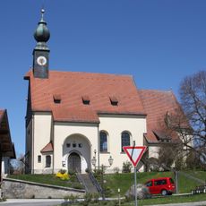
St. Michael
1.2 km
Wayside cross
954 m
Christianity, wayside shrine
1.2 km
Wayside cross
273 m
Wayside cross
916 mReviews
Visited this place? Tap the stars to rate it and share your experience / photos with the community! Try now! You can cancel it anytime.
Discover hidden gems everywhere you go!
From secret cafés to breathtaking viewpoints, skip the crowded tourist spots and find places that match your style. Our app makes it easy with voice search, smart filtering, route optimization, and insider tips from travelers worldwide. Download now for the complete mobile experience.

A unique approach to discovering new places❞
— Le Figaro
All the places worth exploring❞
— France Info
A tailor-made excursion in just a few clicks❞
— 20 Minutes