
Kapelle, satteldachbau mit Dachreiter, zweites Viertel 19. Jahrhundert; mit Kirchenausstattung
Location: Hunding
Address: Eschbügelweg
GPS coordinates: 48.84353,13.18613
Latest update: November 13, 2025 22:04
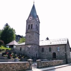
Katholische Pfarrkirche Mariä Himmelfahrt
2.4 km
Feldkapelle
2.3 km
Kapelle
434 m
Kapelle
2.1 km
Kapellenbildstock
1.9 km
Waldlerhaus
2 km
Totenbrettergruppe
2.3 km
Kriegerdenkmal
2.4 km
Stallstadel Dorfstraße 8 in Hunding (Niederbayern)
2.1 km
Friedhofsmauer Langfurth 37 in Schöfweg
2.3 km
Erdkeller
1.8 km
Bauernhaus
2.1 km
Wayside cross
1.8 km
Ruins
1.2 km
Scenic viewpoint
2.4 km
Schiller
1.8 km
Wayside cross
2 km
Josefistafel
2.4 km
Wayside cross
2.1 km
Langfurt
1.7 km
Wayside cross
1.7 km
Memorial
1.7 km
Ruins
1.1 km
Ruins
1.1 km
Padlinger Rachelweg
1.2 km
Memorial, war memorial
645 m
Wayside cross
1.8 km
Memorial cross, memorial
1.7 kmReviews
Visited this place? Tap the stars to rate it and share your experience / photos with the community! Try now! You can cancel it anytime.
Discover hidden gems everywhere you go!
From secret cafés to breathtaking viewpoints, skip the crowded tourist spots and find places that match your style. Our app makes it easy with voice search, smart filtering, route optimization, and insider tips from travelers worldwide. Download now for the complete mobile experience.

A unique approach to discovering new places❞
— Le Figaro
All the places worth exploring❞
— France Info
A tailor-made excursion in just a few clicks❞
— 20 Minutes