
Bildstock, steinsäule mit Laterne, bezeichnet 1631
Location: Jandelsbrunn
Address: zwischen Höllmühle und Ödhof
GPS coordinates: 48.76223,13.65729
Latest update: November 18, 2025 19:30
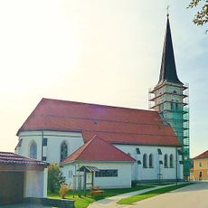
Katholische Pfarrkirche St. Maria Hilfe der Christen
1.1 km
Ehemalige Wallfahrtskapelle St. Koloman
1.2 km
Wasserleitung
774 m
Einzelhof
959 m
Bildstock
960 m
Bildstock
857 m
Cultural heritage D-2-7247-0143 in Grainet
1.2 km
Cultural heritage D-2-7247-0157 in Grainet
1.9 km
Cultural heritage D-2-7247-0159 in Waldkirchen
1.8 km
Bauernhaus
886 m
Backofenhäuschen
849 m
Ausstattung des Vorgängerbaus
1 km
Friedhofsmauer Kirchplatz 1 in Jandelsbrunn
1.1 km
Breche Hofstattacker in Waldkirchen
978 m
Bauernhaus
963 m
Scheune Kronwinkel 5 in Grainet
1.3 km
Cultural heritage D-2-7247-0158 in Waldkirchen
1.6 km
Zugehöriger zweigeschossiger Traidkasten mit kleinem Schrot
253 m
Bildstock
614 m
Ehemalige Schmiede
1.3 km
Backofenhäuschen
971 m
Buchmühle
816 m
Traidkasten
782 m
Kornspeicher In Solla in Waldkirchen
801 m
Torhaus Buchmühle 10 in Waldkirchen
813 m
Bauer-Kreuz
1.7 km
Waldkapelle bei Pilgramsberg
329 m
Wayside cross
1.5 kmVisited this place? Tap the stars to rate it and share your experience / photos with the community! Try now! You can cancel it anytime.
Discover hidden gems everywhere you go!
From secret cafés to breathtaking viewpoints, skip the crowded tourist spots and find places that match your style. Our app makes it easy with voice search, smart filtering, route optimization, and insider tips from travelers worldwide. Download now for the complete mobile experience.

A unique approach to discovering new places❞
— Le Figaro
All the places worth exploring❞
— France Info
A tailor-made excursion in just a few clicks❞
— 20 Minutes