
Bauernhaus, building in Neuhaus am Inn, Lower Bavaria, Germany
Location: Neuhaus am Inn
Address: Abt-Rumpler-Straße 16
GPS coordinates: 48.48586,13.43689
Latest update: November 15, 2025 13:37

Vornbach Abbey
399 m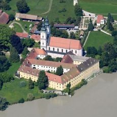
Schloss Vornbach
397 m
Burg Vornbach
399 m
Denkmal Maria am Sand 7 in Neuhaus am Inn
334 m
Cultural heritage D-2-7546-0115 in Neuhaus am Inn
373 m
Bauernhof Schauerödstraße 4 in Neuhaus am Inn
288 m
Baudenkmal D-2-75-134-32 in Neuhaus a.Inn
397 m
Wohnhaus
116 m
Bauernhaus
186 m
Einfriedung Maria am Sand 7 in Neuhaus am Inn
254 m
Cultural heritage D-2-7546-0126 in Neuhaus am Inn
379 m
Gartentempel Maria am Sand 7 in Neuhaus am Inn
242 m
Hoftor Maria am Sand 7 in Neuhaus am Inn
332 m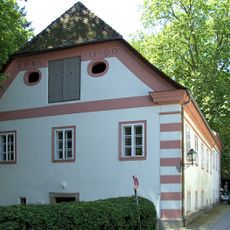
Hofrichterhaus
264 m
Wohnhaus
91 m
Satteldachbau
95 m
Ehem. Taferne
79 m
Mariensäule
343 m
Wohnhaus
195 m
Ehem. Wirtschaftsflügel der Abtei
297 m
Bauernhaus
127 m
Einfirsthof
294 m
Wohnhaus
158 m
Wohnhaus mit Flachdach und Blockbau-Obergeschoss
186 m
Zehentstadel und Kasten
246 m
Nebengebäude Maria am Sand 6; Maria am Sand 6 b in Neuhaus am Inn
361 m
Schlosspark Maria am Sand 7 in Neuhaus am Inn
281 m
Wayside cross
354 mReviews
Visited this place? Tap the stars to rate it and share your experience / photos with the community! Try now! You can cancel it anytime.
Discover hidden gems everywhere you go!
From secret cafés to breathtaking viewpoints, skip the crowded tourist spots and find places that match your style. Our app makes it easy with voice search, smart filtering, route optimization, and insider tips from travelers worldwide. Download now for the complete mobile experience.

A unique approach to discovering new places❞
— Le Figaro
All the places worth exploring❞
— France Info
A tailor-made excursion in just a few clicks❞
— 20 Minutes