Njallavárnjavvi, rapids in Tana, Finnmark, Norway
Location: Tana Municipality
GPS coordinates: 70.09236,27.95867
Latest update: November 11, 2025 17:17
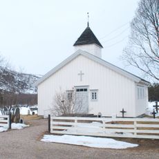
Polmak Church
2.4 km
Tana museum
2.8 km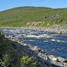
Storfossen
10.6 km
Ruossagárggu
11.8 km
Giddegárgot
4.6 km
Buolbmátsátku
3.1 km
Guoikkaoaivi
11 km
Guivvašguoika
11.3 km
Fálisgeađgi
5.7 km
Ciikojohgoržžit
11.9 km
Giedderiddu
2.8 km
Girkonuorri
2.4 km
Girkogárggu
2.2 km
Njallavárriddu
578 m
Geassegárggu
6.1 km
Issátgárggu
5.6 km
Čohkkángeađgi
4.6 km
Ensligtinden
9.9 km
Áddjágárggu
10.6 km
Fanasgárggu
4.5 km
Ciikujåkgårŋit
11.9 km
Hillagurra
1.6 km
POLMAK GJESTESTUE, Tana museum
2.8 km
Polmak
2.4 km
PAALJORDEN
3.5 km
Suomen pohjoisin kohta
315 m
Esihistoriallinen asuinpaikka
9.8 km
Esihistoriallinen asuinpaikka
9.9 kmReviews
Visited this place? Tap the stars to rate it and share your experience / photos with the community! Try now! You can cancel it anytime.
Discover hidden gems everywhere you go!
From secret cafés to breathtaking viewpoints, skip the crowded tourist spots and find places that match your style. Our app makes it easy with voice search, smart filtering, route optimization, and insider tips from travelers worldwide. Download now for the complete mobile experience.

A unique approach to discovering new places❞
— Le Figaro
All the places worth exploring❞
— France Info
A tailor-made excursion in just a few clicks❞
— 20 Minutes