Rødholman, protected area in Norway
Location: Flekkefjord Municipality
Inception: March 28, 1980
GPS coordinates: 58.23850,6.66900
Latest update: November 4, 2025 06:28
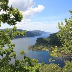
Fedafjorden
3.7 km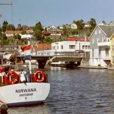
Stolsfjorden
609 m
Øvre og Nedre Svinholmen
630 m
Hobmannen
5.7 km
Bekkjedal
5.6 km
Store Håland
5.9 km
Kalven
4.8 km
Nuland
5.6 km
Haugeland
3.2 km
Kvelland
2.3 km
Urstad Øvre
5.3 km
Fensglåva
5.3 km
Låmannsteinen
5.1 km
Haugelands kvednehus
3.7 km
Mørketjødnåsen
4.1 km
Kalven
5 km
Kalven
5 km
Langelandsfjellet
4.6 km
Plistresteinen
2.1 km
Skodvarden
1.3 km
Kvellands kvednehus
2.1 km
Itlands kvednehus
5.5 km
Store Hålands kvednehus
5.5 km
Langeland
3.5 km
Stolsåta
3 km
Nuland besøksgård
5.8 km
Teigetjødna
5.2 km
Hummarås
5.8 kmReviews
Visited this place? Tap the stars to rate it and share your experience / photos with the community! Try now! You can cancel it anytime.
Discover hidden gems everywhere you go!
From secret cafés to breathtaking viewpoints, skip the crowded tourist spots and find places that match your style. Our app makes it easy with voice search, smart filtering, route optimization, and insider tips from travelers worldwide. Download now for the complete mobile experience.

A unique approach to discovering new places❞
— Le Figaro
All the places worth exploring❞
— France Info
A tailor-made excursion in just a few clicks❞
— 20 Minutes