Gjølertangen, protected area in Norway
Location: Hvaler
Inception: April 16, 2010
GPS coordinates: 58.99800,11.08200
Latest update: November 1, 2025 08:44
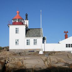
Homlungen Lighthouse
3.9 km
Tjurholmsknappen
2.7 km
Skee 1569:1
4.6 km
Hogdal 82:2
2.5 km
Hogdal 79:1
2.6 km
Skee 21:1
4.2 km
Hogdal 138:1
3.9 km
Skee 1569:2
4.6 km
Skee 23:2
4.7 km
Hogdal 84:1
2.6 km
Skee 1569:4
4.6 km
Hogdal 76:1
4.4 km
Hogdal 77:1
2.6 km
Hogdal 254:1
3.4 km
Hogdal 127:2
4.4 km
Skee 23:1
4.7 km
Skee 22:3
4.4 km
Skee 22:1
4.4 km
Hogdal 127:1
4.4 km
Hogdal 82:1
2.5 km
Hogdal 79:3
2.6 km
Skee 1569:3
4.6 km
Skee 15:1
3.9 km
Karl den XII:s skansar?
1.7 km
Hogdal 130:1
4.4 km
Karl den XII:s skansar?
1.8 km
Skee 859:1
3.3 km
Hogdal 132:1
2.5 kmReviews
Visited this place? Tap the stars to rate it and share your experience / photos with the community! Try now! You can cancel it anytime.
Discover hidden gems everywhere you go!
From secret cafés to breathtaking viewpoints, skip the crowded tourist spots and find places that match your style. Our app makes it easy with voice search, smart filtering, route optimization, and insider tips from travelers worldwide. Download now for the complete mobile experience.

A unique approach to discovering new places❞
— Le Figaro
All the places worth exploring❞
— France Info
A tailor-made excursion in just a few clicks❞
— 20 Minutes