Åpta, dam in Farsund, Noorwegen
Location: Farsund Municipality
GPS coordinates: 58.18794,6.78926
Latest update: November 11, 2025 21:16
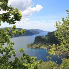
Fedafjorden
5.3 km
Åpta misjonssenter
425 m
Listeid
4.9 km
Terneholmen
4.2 km
Framvaren
4.2 km
Hunnerfjellan
4.9 km
Sarpa
2.4 km
Svindal
3.5 km
Jordkjeller
3.1 km
Handeland
3.9 km
Kvålshei
1.3 km
Strondebakkjen
4.9 km
Runefjellet
4 km
Gryda
2.8 km
Vedremarks kvednehus
4.6 km
Åpta
532 m
Gjervoldstad
2.6 km
Røyneskogen
3.2 km
Tvitjødn
3.4 km
Gjervoldstad
2.6 km
Håland
4.8 km
Skjoldals og Austads kvernehus
4.9 km
Krossbergjet
4.9 km
Reiet
4.7 km
Briseid
3.9 km
Tuppa på haugen
3.4 km
Scenic viewpoint
869 m
Åptefossen
705 mReviews
Visited this place? Tap the stars to rate it and share your experience / photos with the community! Try now! You can cancel it anytime.
Discover hidden gems everywhere you go!
From secret cafés to breathtaking viewpoints, skip the crowded tourist spots and find places that match your style. Our app makes it easy with voice search, smart filtering, route optimization, and insider tips from travelers worldwide. Download now for the complete mobile experience.

A unique approach to discovering new places❞
— Le Figaro
All the places worth exploring❞
— France Info
A tailor-made excursion in just a few clicks❞
— 20 Minutes