Demning, Kolbu
Location: Østre Toten Municipality
GPS coordinates: 60.64790,10.75486
Latest update: November 3, 2025 20:31
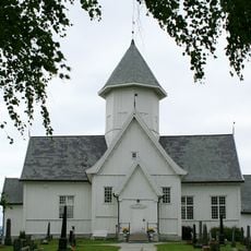
Kolbu Church
2.3 km
Jensengdammen, Narum
567 m
Leiruttak, Kolbu
387 m
Kvernveit, Molstad
2.1 km
Kolbu Meieri
626 m
Kvernveit, Kolbu
281 m
Demning, Molstad
2.2 km
Veit
2.2 km
Narumsverket
408 m
Kvernveit, Kolbu
369 m
Kvernveit
408 m
Fargeri, Kolbu
238 m
Kvernveit, Smedstad
557 m
Hallingstad Mølle og sagbruk
2.5 km
Kvernveit, Molstad
2 km
Smie og frørenseri, Smedstad
687 m
Kvernveit, Kolbu
237 m
Teglverk, Tonga, Kolbu
436 m
Kvernveit, Kolbu
173 m
Kolbu Bruk
279 m
Narum Brenneri
380 m
Dam, Smedstad
483 m
Meieri, Narumsbrua
198 m
Sagbruk, Narumbrua
272 m
Mølle, Molstad
2 km
Brovold Garveri
329 m
Kvernveit, Molstad
2.2 km
Kvernveit, Hallingstad
2.4 kmReviews
Visited this place? Tap the stars to rate it and share your experience / photos with the community! Try now! You can cancel it anytime.
Discover hidden gems everywhere you go!
From secret cafés to breathtaking viewpoints, skip the crowded tourist spots and find places that match your style. Our app makes it easy with voice search, smart filtering, route optimization, and insider tips from travelers worldwide. Download now for the complete mobile experience.

A unique approach to discovering new places❞
— Le Figaro
All the places worth exploring❞
— France Info
A tailor-made excursion in just a few clicks❞
— 20 Minutes