
Varberg 12:4, stone setting in Varberg Municipality, Halland County, Sweden
Location: Varberg Municipality
GPS coordinates: 57.09329,12.27294
Latest update: November 24, 2023 23:09
Nöjesparken, Varberg
909 m
Söderhöjd
571 m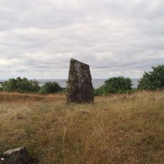
Randens hög
865 m
Varberg 19:2
937 m
Varberg 12:1
40 m
Varberg 17:1
646 m
Varberg 18:2
929 m
Varberg 21:1
929 m
Varberg 18:1
933 m
Varberg 19:1
950 m
Varberg 38:1
864 m
Höga rör
835 m
Varberg 19:3
916 m
Varberg 19:4
928 m
Varberg 72:1
322 m
Varberg 37:1
854 m
Varberg 119:1
318 m
Varberg 72:2
298 m
Varberg 18:3
907 m
Varberg 88:2
249 m
Varberg 11:1
233 m
Varberg 59:1
1.1 km
Varberg 14:2
75 m
Varberg 14:1
76 m
Varberg 12:2
78 m
Varberg 15:1
128 m
Varberg 12:3
109 m
Varberg 20:1
946 mReviews
Visited this place? Tap the stars to rate it and share your experience / photos with the community! Try now! You can cancel it anytime.
Discover hidden gems everywhere you go!
From secret cafés to breathtaking viewpoints, skip the crowded tourist spots and find places that match your style. Our app makes it easy with voice search, smart filtering, route optimization, and insider tips from travelers worldwide. Download now for the complete mobile experience.

A unique approach to discovering new places❞
— Le Figaro
All the places worth exploring❞
— France Info
A tailor-made excursion in just a few clicks❞
— 20 Minutes