Tävelsås 53:1, hällristning i Småland
Location: Växjö Municipality
GPS coordinates: 56.73349,14.75768
Latest update: November 22, 2025 13:27
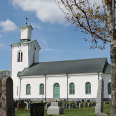
Kalvsvik Church
2.6 km
Kyrkåkern
2.5 km
Tävelsås 259
2.5 km
Kalvsvik 10:1
2.6 km
Tävelsås 129:1
2.3 km
Kalvsvik 130:1
1.6 km
Tävelsås 119:1
2.9 km
Tävelsås 120:1
2.9 km
Ekekullen
2.5 km
Kalvsvik 1:1
1.7 km
Tävelsås 78:1
1.5 km
Tävelsås 304
2.8 km
Tävelsås 201
1.9 km
Tävelsås 55:1
3.1 km
Humlekull
2.2 km
Tävelsås 53:2
9 m
Jät 135:1
2.9 km
Tävelsås 76:2
2.7 km
Tävelsås 76:1
2.7 km
Tävelsås 199
2.3 km
Kung Alles borg
1.7 km
Kalvsvik 22:1
2.2 km
Tävelsås 18:1
1.5 km
Tävelsås 119:2
2.9 km
Kalvsvik 66:1
2.7 km
Guldbacken
3.1 km
Tävelsås 298
2.3 km
Tävelsås 100:1
2.4 kmReviews
Visited this place? Tap the stars to rate it and share your experience / photos with the community! Try now! You can cancel it anytime.
Discover hidden gems everywhere you go!
From secret cafés to breathtaking viewpoints, skip the crowded tourist spots and find places that match your style. Our app makes it easy with voice search, smart filtering, route optimization, and insider tips from travelers worldwide. Download now for the complete mobile experience.

A unique approach to discovering new places❞
— Le Figaro
All the places worth exploring❞
— France Info
A tailor-made excursion in just a few clicks❞
— 20 Minutes