Remmene 3:2, stenkrets i Västergötland
Location: Herrljunga Municipality
GPS coordinates: 58.06553,12.94863
Latest update: November 24, 2023 23:10

Remmene 5:1
209 m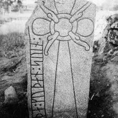
Runristning Vg 156 Remmene kyrkogård
360 m
Norskullen
597 m
Remmene 98:1
714 m
Remmene 27:1
1.2 km
Gåsakullen
881 m
Remmene 86:3
718 m
Remmene 109:1
618 m
Remmene 96:2
1.1 km
Remmene 89:2
1.3 km
Remmene 90:1
1.3 km
Remmene 89:3
1.3 km
Remmene 86:1
733 m
Remmene 86:2
744 m
Remmene 2:1
822 m
Remmene 95:1
831 m
Remmene 24:1
1 km
Remmene 120:1
921 m
Remmenedal
1 km
Remmene 4:1
609 m
Remmene 18:1
387 m
Remmene 3:1
26 m
Tarsled 5:1
1.2 km
Remmene 96:1
1.2 km
Rösås
1.3 km
Remmene 89:1
1.3 km
Norskullen
594 m
Remmene 86:5
723 mReviews
Visited this place? Tap the stars to rate it and share your experience / photos with the community! Try now! You can cancel it anytime.
Discover hidden gems everywhere you go!
From secret cafés to breathtaking viewpoints, skip the crowded tourist spots and find places that match your style. Our app makes it easy with voice search, smart filtering, route optimization, and insider tips from travelers worldwide. Download now for the complete mobile experience.

A unique approach to discovering new places❞
— Le Figaro
All the places worth exploring❞
— France Info
A tailor-made excursion in just a few clicks❞
— 20 Minutes