Tostared 9:1, cemetery in Mark Municipality, Västra Götaland County, Sweden
Location: Mark Municipality
GPS coordinates: 57.46725,12.38073
Latest update: November 17, 2025 02:34
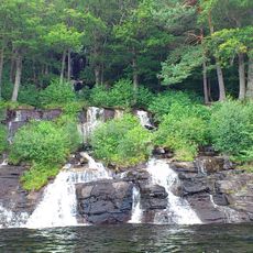
Ramhultafallet
5.5 km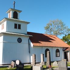
Tostared Church
586 m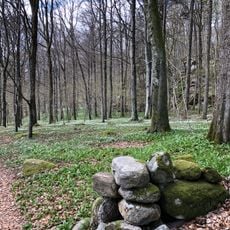
Årenäs-Tostekulla lövskogar
3.3 km
Öxared
4.7 km
Oxhagen
4 km
Kungsstenen
5.6 km
Kungsstenen
5.6 km
Surteby-Kattunga 36:1
4.5 km
Förlanda 59:1
4.6 km
Fjärås 232:1
5.3 km
Förlanda 123:1
4.6 km
Surteby-Kattunga 64:1
4.7 km
Fjärås 161:1
5.3 km
Tostared 20:1
2.7 km
Fjärås 233:1
4.4 km
Förlanda 29:1
5.1 km
Förlanda 38:1
4.3 km
Förlanda 22:1
5.7 km
Fjärås 231:1
5.3 km
Förlanda 123:2
4.6 km
Fotskäl 97:1
5.7 km
Förlanda 23:1
3.3 km
Surteby-Kattunga 37:1
4.6 km
Sätila 201:1
5.9 km
Fjärås 236:1
5.9 km
Fjärås 230:1
5.3 km
Förlanda 22:2
5.7 km
Scenic viewpoint
3.7 kmReviews
Visited this place? Tap the stars to rate it and share your experience / photos with the community! Try now! You can cancel it anytime.
Discover hidden gems everywhere you go!
From secret cafés to breathtaking viewpoints, skip the crowded tourist spots and find places that match your style. Our app makes it easy with voice search, smart filtering, route optimization, and insider tips from travelers worldwide. Download now for the complete mobile experience.

A unique approach to discovering new places❞
— Le Figaro
All the places worth exploring❞
— France Info
A tailor-made excursion in just a few clicks❞
— 20 Minutes