Skepplanda 131:4, hällristning i Västergötland
Location: Ale Municipality
GPS coordinates: 57.97392,12.20690
Latest update: November 21, 2025 09:03
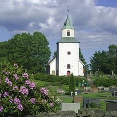
Skepplanda Church
1.5 km
Sålanda and Ryk
1.8 km
Skepplanda 44:1
1.9 km
Kungsgraven
1.7 km
Skepplanda 106:1
1.9 km
Skepplanda 153:1
1.9 km
Skepplanda 101:1
1.8 km
Smörkullen
1.4 km
Skepplanda 131:1
40 m
Skepplanda hemvärns- och kulturförening, militärhistoriskt museum
394 m
Skepplanda 41:1
1.7 km
Skepplanda 104:1
870 m
Skepplanda 190:1
378 m
Skepplanda 153:2
1.9 km
Skepplanda 106:2
1.9 km
Skepplanda 131:3
10 m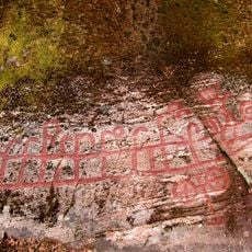
Skepplanda 20:1
367 m
Skepplanda 107:1
1.8 km
Skepplanda 13:1
1.2 km
Skepplanda 129:1
194 m
Skepplanda 108:1
1.8 km
Skepplanda 131:2
43 m
Skepplanda 22:1
1.7 km
Skepplanda 177:1
1.5 km
Skepplanda 105:1
1.9 km
Skepplanda 191:1
1.8 km
Skepplanda 8:1
933 m
Starrkärr 133:1
1.7 kmReviews
Visited this place? Tap the stars to rate it and share your experience / photos with the community! Try now! You can cancel it anytime.
Discover hidden gems everywhere you go!
From secret cafés to breathtaking viewpoints, skip the crowded tourist spots and find places that match your style. Our app makes it easy with voice search, smart filtering, route optimization, and insider tips from travelers worldwide. Download now for the complete mobile experience.

A unique approach to discovering new places❞
— Le Figaro
All the places worth exploring❞
— France Info
A tailor-made excursion in just a few clicks❞
— 20 Minutes