Rångedala 141:1, hällristning i Västergötland
Location: Borås Municipality
GPS coordinates: 57.77653,13.08528
Latest update: November 21, 2025 00:42
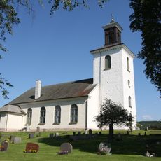
Rångedala Church
2.7 km
Gingri 25:1
2.5 km
Forngraven
2.4 km
Rångedala 132:1
349 m
Rångedala 34:1
1.1 km
Rångedala 74:1
2.8 km
Rångedala 120:2
2.2 km
Bigra rör, Igla rör
2 km
Gingri 11:1
2.5 km
Rångedala 173:2
1.6 km
Rångedala 147:1
2.1 km
Rångedala 10:1
2.8 km
Rångedala 140:1
285 m
Toarp 13:1
2.9 km
Toarp 5:2
2.8 km
Rångedala 76:1
2.4 km
Altaret
2.1 km
Rångedala 16:1
1.3 km
Rångedala 139:1
460 m
Rångedala 30:1
2.9 km
Rångedala 143:1
1.3 km
Rångedala 154:1
2.6 km
Rångedala 165:1
1.5 km
Rångedala 27:1
961 m
Rångedala 128:1
2 km
Brämhult 9:1
2.5 km
Falskog
1.4 km
Rångedala 25:1
1.2 kmReviews
Visited this place? Tap the stars to rate it and share your experience / photos with the community! Try now! You can cancel it anytime.
Discover hidden gems everywhere you go!
From secret cafés to breathtaking viewpoints, skip the crowded tourist spots and find places that match your style. Our app makes it easy with voice search, smart filtering, route optimization, and insider tips from travelers worldwide. Download now for the complete mobile experience.

A unique approach to discovering new places❞
— Le Figaro
All the places worth exploring❞
— France Info
A tailor-made excursion in just a few clicks❞
— 20 Minutes