Trollhättan 166:1, stone setting in Trollhättan Municipality, Älvsborg County, Sweden
Location: Trollhättan Municipality
GPS coordinates: 58.27833,12.26225
Latest update: November 22, 2025 16:25
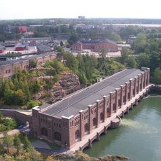
Olidan Hydroelectric Power Station
746 m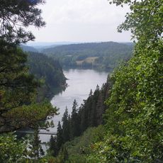
Älvrummet
355 m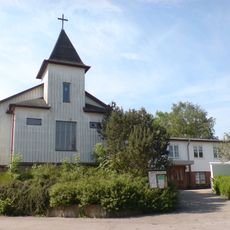
Immanuelskyrkan, Trollhättan
618 m
Trollhättan 50:1
336 m
Trollhättan 38:1
664 m
Trollhättan 50:2
326 m
Trollhättan 51:1
540 m
Trollhättan 170:1
404 m
Trollhättan 171:2
579 m
Trollhättan 171:1
578 m
Trollhättan 41:1
587 m
Trollhättan 40:1
694 m
Trollhättan 39:1
615 m
Trollhättan 37:1
551 m
Trollhättan 48:1
511 m
Trollhättan 49:1
582 m
Trollhättan 49:2
604 m
Scenic viewpoint
491 m
Scenic viewpoint
552 m
Bench, scenic viewpoint
683 m
Scenic viewpoint
562 m
Scenic viewpoint
443 m
Kopparklinten
586 m
Scenic viewpoint
615 m
Scenic viewpoint
630 m
Bench, scenic viewpoint
476 m
Bench, scenic viewpoint
690 m
Scenic viewpoint
742 mReviews
Visited this place? Tap the stars to rate it and share your experience / photos with the community! Try now! You can cancel it anytime.
Discover hidden gems everywhere you go!
From secret cafés to breathtaking viewpoints, skip the crowded tourist spots and find places that match your style. Our app makes it easy with voice search, smart filtering, route optimization, and insider tips from travelers worldwide. Download now for the complete mobile experience.

A unique approach to discovering new places❞
— Le Figaro
All the places worth exploring❞
— France Info
A tailor-made excursion in just a few clicks❞
— 20 Minutes