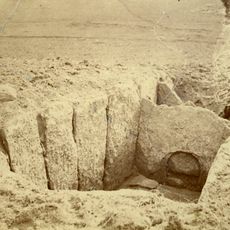
Karleby 83:1, stenkammargrav i Västergötland
Location: Falköping Municipality
GPS coordinates: 58.16723,13.63280
Latest update: November 23, 2025 05:11
Utbogårdens hällkista
944 m
Djupadalen, Karleby
702 m
Karleby 106:1
644 m
Karleby 77:1
562 m
Karleby 77:2
562 m
Karleby 81:1
355 m
Falköpings östra 19:1
1 km
Karleby 123:3
1.1 km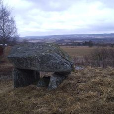
Karleby 76:1
689 m
Elins sten el Ilia sten
266 m
Karleby 84:1
489 m
Elins sten el Ilia sten
266 m
Elins sten el Ilia sten
266 m
Falköpings östra 22:1
1.1 km
Falköpings östra 21:1
1 km
Karleby 86:1
964 m
Falköpings östra 19:3
1.1 km
Karleby 133:1
1 km
Karleby 74:2
1.1 km
Karleby 74:3
1.1 km
Karleby 89:1
1 km
Karleby 74:1
1.1 km
Falköpings östra 19:2
1 km
Karleby 87:1
661 m
Karleby 74:4
1.1 km
Karleby 134:1
1.1 km
Karleby 75:1
732 m
Karleby 73:1
990 mReviews
Visited this place? Tap the stars to rate it and share your experience / photos with the community! Try now! You can cancel it anytime.
Discover hidden gems everywhere you go!
From secret cafés to breathtaking viewpoints, skip the crowded tourist spots and find places that match your style. Our app makes it easy with voice search, smart filtering, route optimization, and insider tips from travelers worldwide. Download now for the complete mobile experience.

A unique approach to discovering new places❞
— Le Figaro
All the places worth exploring❞
— France Info
A tailor-made excursion in just a few clicks❞
— 20 Minutes