Rämma rös, röse i Bohuslän (Jörlanda 33:1)
Location: Stenungsund Municipality
GPS coordinates: 57.96343,11.86311
Latest update: October 25, 2025 16:15
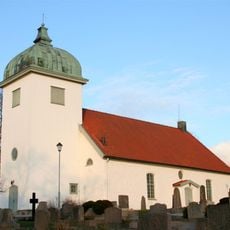
Jörlanda Church
3 km
Solberga 262:6
3 km
Solberga 297:5
2.1 km
Solberga 298:1
2 km
Jörlanda 139:1
2.8 km
Solberga 297:2
2.1 km
Solberga 271:2
2.9 km
Solberga 213:3
2.5 km
Solberga 213:1
2.5 km
Solberga 262:7
3 km
Solberga 262:9
3 km
Jörlanda 354:1
2.5 km
Solberga 297:1
2.1 km
Jörlanda 12:1
2.4 km
Solberga 210:1
2.7 km
Solberga 297:3
2.1 km
Jörlanda 347:1
2.2 km
Solberga 76:1
1.7 km
Solberga 70:1
2.5 km
Solberga 271:1
2.9 km
Solberga 297:6
2.1 km
Jörlanda 37:1
1.7 km
Solberga 297:4
2.2 km
Jörlanda 350:1
1.8 km
Jörlanda 350:2
1.8 km
Jörlanda 351:1
2 km
Jörlanda 352:1
1.9 km
Solberga 213:2
2.5 kmReviews
Visited this place? Tap the stars to rate it and share your experience / photos with the community! Try now! You can cancel it anytime.
Discover hidden gems everywhere you go!
From secret cafés to breathtaking viewpoints, skip the crowded tourist spots and find places that match your style. Our app makes it easy with voice search, smart filtering, route optimization, and insider tips from travelers worldwide. Download now for the complete mobile experience.

A unique approach to discovering new places❞
— Le Figaro
All the places worth exploring❞
— France Info
A tailor-made excursion in just a few clicks❞
— 20 Minutes