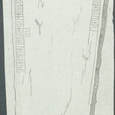
Långtora 17:1, hällristning i Uppland
Location: Enköping Municipality
GPS coordinates: 59.72627,17.11650
Latest update: October 25, 2025 15:37
Uppland Runic Inscription 799
1.8 km
Uppland Runic Inscription 804
2.1 km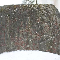
Uppland Runic Inscription 802
1.8 km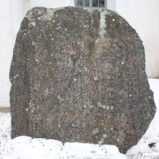
Uppland Runic Inscription 800
1.8 km
Vårfrukyrka 218:1
2.4 km
Härnevi 75:1
2.1 km
Långtora 23:1
1.3 km
Långtora 24:1
1.2 km
Långtora 25:1
1.2 km
Torstuna 101:1
2.4 km
Långtora 26:2
1.1 km
Vårfrukyrka 278:1
2.2 km
Vårfrukyrka 275:1
2.3 km
Härnevi 82:1
1.9 km
Långtora 19:1
384 m
Härnevi 59:1
1.8 km
Härnevi 57:2
1.5 km
Långtora 59:1
2.4 km
Långtora 26:3
1.1 km
Torstuna 101:2
2.4 km
Långtora 15:1
699 m
Långtora 121:1
602 m
Vårfrukyrka 277:1
2.3 km
Långtora 26:1
1.1 km
Långtora 9:1
1.9 km
Långtora 120:1
563 m
Långtora 120:2
563 m
Långtora 122:1
421 mReviews
Visited this place? Tap the stars to rate it and share your experience / photos with the community! Try now! You can cancel it anytime.
Discover hidden gems everywhere you go!
From secret cafés to breathtaking viewpoints, skip the crowded tourist spots and find places that match your style. Our app makes it easy with voice search, smart filtering, route optimization, and insider tips from travelers worldwide. Download now for the complete mobile experience.

A unique approach to discovering new places❞
— Le Figaro
All the places worth exploring❞
— France Info
A tailor-made excursion in just a few clicks❞
— 20 Minutes