Västra Frölunda 1:1, röse i Västergötland
Location: Gothenburg Municipality
GPS coordinates: 57.61120,11.88897
Latest update: November 7, 2025 15:25
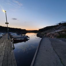
Rörviksbadet
2.1 km
Public beach Näset
807 m
Västra Frölunda 5:1
706 m
Västra Frölunda 4:1
326 m
Askim 46:1
2.1 km
Västra Frölunda 6:1
1.1 km
Askim 29:1
2.2 km
Ganlebukten
2.1 km
Västra Frölunda 186:1
1.5 km
Askim 45:1
2 km
Askim 32:1
2.2 km
Askim 30:3
2.2 km
Askim 30:2
2.2 km
Askim 57:2
1.9 km
Askim 57:1
1.9 km
Västra Frölunda 2:1
897 m
Västra Frölunda 376:1
813 m
Västra Frölunda 3:1
1 km
Askim 48:1
2.1 km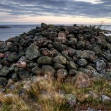
Västra Frölunda 1:2
23 m
Tullvaktarstugan
353 m
Västra Frölunda 1:3
24 m
Västra Frölunda 7:1
1.2 km
Västra Frölunda 151:1
719 m
Västergårds vale
1.4 km
Rumpen
2 km
Smithska udden
521 m
Scenic viewpoint
1.9 kmReviews
Visited this place? Tap the stars to rate it and share your experience / photos with the community! Try now! You can cancel it anytime.
Discover hidden gems everywhere you go!
From secret cafés to breathtaking viewpoints, skip the crowded tourist spots and find places that match your style. Our app makes it easy with voice search, smart filtering, route optimization, and insider tips from travelers worldwide. Download now for the complete mobile experience.

A unique approach to discovering new places❞
— Le Figaro
All the places worth exploring❞
— France Info
A tailor-made excursion in just a few clicks❞
— 20 Minutes