Ölserud 119, hällbild i Värmland
Location: Säffle Municipality
GPS coordinates: 59.02239,13.12454
Latest update: October 28, 2025 01:47
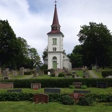
Ölseruds kyrka
667 m
Millesvik 11:1
3.6 km
Millesvik 181:1
3.7 km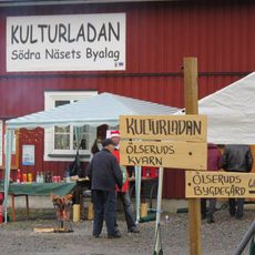
Kulturladan Södra näsets byalag
115 m
Millesvik 104:2
3.6 km
Millesvik 41:1
4.1 km
Botilsäter 44:1
3 km
Botilsäter 36:1
3 km
Botilsäter 23:1
1.3 km
Ölserud 6:3
3.1 km
Millesvik 124:1
3.7 km
Millesvik 108:1
4.8 km
Millesvik 113:1
4.3 km
Ölserud 6:1
3 km
Ölserud 6:2
3 km
Millesvik 120:1
4.4 km
Ölserud 7:1
3.3 km
Ölserud 10:1
2 km
Ölserud 15:1
2.9 km
Botilsäter 12:1
3.4 km
Ölserud 4:1
3.1 km
Millesvik 104:1
3.6 km
Botilsäter 39:1
4.8 km
Botilsäter 39:2
4.8 km
Botilsäter 39:3
4.8 km
Millesvik 49:1
4 km
Botilsäter 45:1
3.9 km
Millesvik 40:1
4.1 kmReviews
Visited this place? Tap the stars to rate it and share your experience / photos with the community! Try now! You can cancel it anytime.
Discover hidden gems everywhere you go!
From secret cafés to breathtaking viewpoints, skip the crowded tourist spots and find places that match your style. Our app makes it easy with voice search, smart filtering, route optimization, and insider tips from travelers worldwide. Download now for the complete mobile experience.

A unique approach to discovering new places❞
— Le Figaro
All the places worth exploring❞
— France Info
A tailor-made excursion in just a few clicks❞
— 20 Minutes