
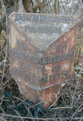
Milepost At National Grid Reference So577403, milestone in Dormington, County of Herefordshire, UK
Location: Dormington
Inception: 19 century
GPS coordinates: 52.05937,-2.61829
Latest update: March 5, 2025 21:36

Stoke Edith House
2.8 km
Longworth Roman Catholic Chapel
905 m
The New Inn
1.9 km
The Moon Inn
3 km
Church of St Mary
2.7 km
Church of the Holy Rood
2.9 km
Church of St Andrew
2.9 km
Church of St Peter
620 m
Church of St Peter
2.7 km
Church of St John Baptist
1.2 km
The Old Post Office
3 km
The White Stone And Fragment Of Base Immediately To The East
2.8 km
Convent Of Our Lady Of Charity
910 m
Sufton Court
2.4 km
Mordiford Bridge
2.9 km
Longworth Hall
1.5 km
Lugwardine War Memorial
2.7 km
Churchyard cross in St Andrew's churchyard
2.9 km
Milepost At So593246
1.6 km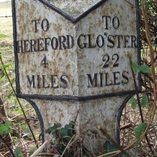
Milepost At S0568375
3 km
Churchyard Cross
2.7 km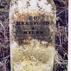
Mile Stone About 250 Yards East-North-East Of The White Stone
3 km
Churchyard cross in Holy Rood churchyard
2.9 km
The Steps Farmhouse
2.5 km
Guidestone, Mordiford Bridge
2.9 km
Milestone, Whitestone House, White Stone Cross
2.7 km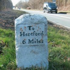
Milestone, Castle Farm at SO59224275
2.9 km
Milepost, opp church, jct with Lumber Lane
2.7 kmReviews
Visited this place? Tap the stars to rate it and share your experience / photos with the community! Try now! You can cancel it anytime.
Discover hidden gems everywhere you go!
From secret cafés to breathtaking viewpoints, skip the crowded tourist spots and find places that match your style. Our app makes it easy with voice search, smart filtering, route optimization, and insider tips from travelers worldwide. Download now for the complete mobile experience.

A unique approach to discovering new places❞
— Le Figaro
All the places worth exploring❞
— France Info
A tailor-made excursion in just a few clicks❞
— 20 Minutes