Schläde-Berg, Berg in Losheim am See
Location: Losheim am See
Elevation above the sea: 376.6 m
GPS coordinates: 49.47689,6.75804
Latest update: November 20, 2025 01:32

St. Andreas
3 km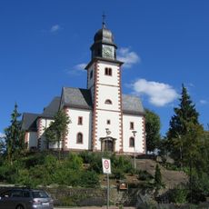
St. Helena
2.1 km
Heilig-Kreuz-Kirche
2.6 km
St. Blasius
977 m
Hungers-Berg
2.4 km
Grosser Lueckner zwischen Beckingen-Oppen und Losheim-Wahlen
2.6 km
Landschaftsschutzgebiet "Bei Rimlingen und Rissenthal" (L 6506-306)
709 m
Bei Rimlingen und Rissenthal
668 m
Wayside cross
3 km
Gefallene WW1
2.8 km
Scenic viewpoint
2.9 km
Scenic viewpoint
1.5 km
Wayside cross
2.1 km
Wayside cross
246 m
Bronzeplastik
2.4 km
Wegkreuz
1.7 km
Gefallene WW1
2.8 km
Scenic viewpoint
2.6 km
Grubenunglück 1885
2.8 km
Zur Ehre Gottes
2.9 km
Wayside cross
1.9 km
Catholic church building, wayside cross, Christianity
2.8 km
Catholic church building, wayside cross, Christianity
2.7 km
Catholic church building, wayside cross, Christianity
2.2 km
Wayside cross
3 km
Memorial, memorial stone
303 m
Wayside cross
1.3 km
Wayside cross
1.7 kmReviews
Visited this place? Tap the stars to rate it and share your experience / photos with the community! Try now! You can cancel it anytime.
Discover hidden gems everywhere you go!
From secret cafés to breathtaking viewpoints, skip the crowded tourist spots and find places that match your style. Our app makes it easy with voice search, smart filtering, route optimization, and insider tips from travelers worldwide. Download now for the complete mobile experience.

A unique approach to discovering new places❞
— Le Figaro
All the places worth exploring❞
— France Info
A tailor-made excursion in just a few clicks❞
— 20 Minutes