Klapper-Berg, Berg im Saarland
Location: Lebach
Elevation above the sea: 420.2 m
GPS coordinates: 49.45538,6.93701
Latest update: November 20, 2025 02:59
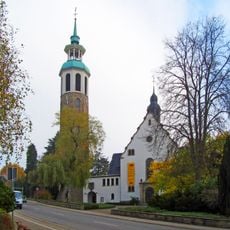
St. Aloysius
1.8 km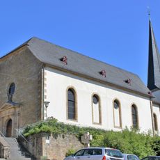
St. Alban
2.1 km
Klinkberg
1.3 km
Naturschutzgebiet "Kuhnenwald-Huhngrund" (N 6507-305)
1.6 km
Ebert
1.1 km
Naturschutzgebiet "Südlicher Klapperberg - Im Schachen" (N 6507-303)
517 m
Donnerhübel
720 m
NSG Kuhnenwald-Huhngrund
954 m
Landschaftsschutzgebiet im Landkreis Saarlouis - im Bereich der Gemeinde Schmelz (und Lebach)
1.7 km
Steinbach - Truppenübungsgelände
1.9 km
Südlicher Klapperberg - Im Schachen
537 m
Steinbach - Truppenübungsgelände
1.8 km
Landschaftsschutzgebiet im Landkreis Saarlouis - im Bereich der Gemeinden (Schmelz und) Lebach
994 m
Statue, Work of art
1.9 km
Wendalinus-Kreuz
2 km
Scenic viewpoint
1.8 km
Gedenkstein Peter Schmitt
1.5 km
Schorrenkreuz
2.2 km
Wegekreuz Thewes
2.1 km
Dewes Kreuz
2.2 km
Steinsäulen
226 m
Wegekreuz Itzbach
2.2 km
Wegekreuz Thewes/Rullof
1.5 km
Wayside cross, Christianity
526 m
Wayside cross, Christianity
801 m
Bungerts-Kreuz
2.2 km
Wegekreuz Mertes
1.3 km
Kreuz Johann Lesch
2.1 kmReviews
Visited this place? Tap the stars to rate it and share your experience / photos with the community! Try now! You can cancel it anytime.
Discover hidden gems everywhere you go!
From secret cafés to breathtaking viewpoints, skip the crowded tourist spots and find places that match your style. Our app makes it easy with voice search, smart filtering, route optimization, and insider tips from travelers worldwide. Download now for the complete mobile experience.

A unique approach to discovering new places❞
— Le Figaro
All the places worth exploring❞
— France Info
A tailor-made excursion in just a few clicks❞
— 20 Minutes