Kriegerdenkmal, über Treppe erhöhte Anlage mit halbrunder Mauer, Figurenschmuck und Inschrifttafeln, um 1920/25; an der Abzweigung Thalwies
Location: Taching am See
Address: In Tengling
GPS coordinates: 47.99543,12.72700
Latest update: November 20, 2025 14:32
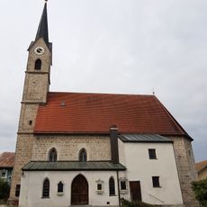
St. Laurentius
112 m
Wegkapelle
348 m
Kapelle
477 m
Cultural heritage D-1-8042-0092 in Taching am See
936 m
Cultural heritage D-1-8042-0049 in Taching am See
219 m
Cultural heritage D-1-8042-0191 in Taching am See
128 m
Austragshaus
455 m
Cultural heritage D-1-8042-0047 in Taching am See
949 m
Wohnhaus
349 m
Kreuz
856 m
Einfirsthof
67 m
Zuhaus
697 m
Wohnstallhaus
286 m
Kapelle Furthmühle 1 in Taching am See
467 m
Cultural heritage D-1-8042-0097 in Taching am See
903 m
Amtshaus Tengling
113 m
Gasthaus zur Post
90 m
Einfirsthof
33 m
Stadel
231 m
Schmales Wohnhaus
135 m
Scheune Untere Dorfstraße 12 in Taching am See
324 m
"Furthmühle"
410 m
Getreidekasten
648 m
Wohnstallhaus
692 m
Cultural heritage D-1-7942-0108 in Taching am See
656 m
Scheune Wimpasing 1 in Taching am See
699 m
Stallstadel Untere Dorfstraße 12 in Taching am See
298 m
Bench, scenic viewpoint
729 mReviews
Visited this place? Tap the stars to rate it and share your experience / photos with the community! Try now! You can cancel it anytime.
Discover hidden gems everywhere you go!
From secret cafés to breathtaking viewpoints, skip the crowded tourist spots and find places that match your style. Our app makes it easy with voice search, smart filtering, route optimization, and insider tips from travelers worldwide. Download now for the complete mobile experience.

A unique approach to discovering new places❞
— Le Figaro
All the places worth exploring❞
— France Info
A tailor-made excursion in just a few clicks❞
— 20 Minutes