Stadel, (Südflügel des Dreiseithofes) mit Gitterbundwerk an der Giebelseite, bezeichnet mit dem Jahr 1893; nördlich frei stehender Getreidekasten, erbaut 1806; zugehörig Hofkapelle, 18./19. Jahrhundert, südlich des Hofes am Ortseingang
Location: Taching am See
Address: Hirschpoint 2
GPS coordinates: 47.96783,12.69267
Latest update: November 20, 2025 23:01

Feldkapelle
1.7 km
Kapelle
618 m
Wegkapelle
1.8 km
Cultural heritage D-1-8042-0037 in Taching am See
1.7 km
Bauernhaus
875 m
Bauernhaus
1.5 km
Feldkapelle
1.8 km
Cultural heritage D-1-8042-0078 in Waging am See
1.7 km
Remise Mollstätten 13 in Taching am See
562 m
Wohnstallhaus
648 m
Bauernhaus
1.5 km
Stadel Hirschpoint 2 in Taching am See
50 m
Cultural heritage D-1-8042-0098 in Taching am See
1.3 km
Bauernhaus Eging 10 in Taching am See
1.5 km
Tuffsteinkreuz
1.4 km
Bundwerkstadel
563 m
Getreidekasten
764 m
Bundwerkstadel
689 m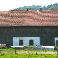
Bundwerkstadel
1.6 km
Schuppen Mollstätten 2 in Taching am See
624 m
Wohnstallhaus Mollstätten 2 in Taching am See
651 m
Stadel Hirschpoint 2 in Taching am See
38 m
Scenic viewpoint
1.5 km
Wayside cross
1.3 km
Wayside cross
976 m
Wayside shrine, Christianity
1.8 km
Wayside cross
800 m
Wayside cross
1.2 kmReviews
Visited this place? Tap the stars to rate it and share your experience / photos with the community! Try now! You can cancel it anytime.
Discover hidden gems everywhere you go!
From secret cafés to breathtaking viewpoints, skip the crowded tourist spots and find places that match your style. Our app makes it easy with voice search, smart filtering, route optimization, and insider tips from travelers worldwide. Download now for the complete mobile experience.

A unique approach to discovering new places❞
— Le Figaro
All the places worth exploring❞
— France Info
A tailor-made excursion in just a few clicks❞
— 20 Minutes