, ehemaliges Bundwerkstadel, mit Gitterbundwerk, Blockbauteil und Bemalung, bezeichnet mit dem Jahr 1841; um 1970 aus Niederham hierher transferiert und zu Wohnzwecken ausgebaut
Location: Pittenhart
Address: Moosweg 10
GPS coordinates: 47.96187,12.41781
Latest update: November 21, 2025 12:00
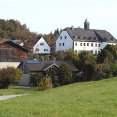
Schloss Oberbrunn
307 m
Turmhügel Eschenau
1.3 km
Cultural heritage D-1-8040-0018 in Pittenhart
410 m
Cultural heritage D-1-8040-0016 in Pittenhart
698 m
Cultural heritage D-1-8040-0119 in Pittenhart
703 m
Cultural heritage D-1-8040-0159 in Pittenhart
1.3 km
Cultural heritage D-1-8040-0251 in Pittenhart
266 m
Hilgerhof
837 m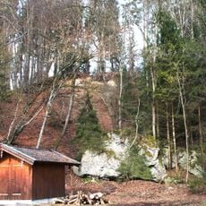
Schottermoräne 700 m NW von Oberbrunn
1 km
Cultural heritage D-1-8040-0011 in Pittenhart
1.3 km
Schuppen Niederbrunn 9 in Pittenhart
800 m
Scheune Niederbrunn 9 in Pittenhart
794 m
Kornspeicher Niederbrunn 9 in Pittenhart
749 m
Schuppen Niederbrunn 12 in Pittenhart
844 m
Scenic viewpoint
1.1 km
Wayside shrine
817 m
Heiliger Petrus
818 m
Wayside cross
891 m
Wayside cross
658 m
Wayside cross
831 mReviews
Visited this place? Tap the stars to rate it and share your experience / photos with the community! Try now! You can cancel it anytime.
Discover hidden gems everywhere you go!
From secret cafés to breathtaking viewpoints, skip the crowded tourist spots and find places that match your style. Our app makes it easy with voice search, smart filtering, route optimization, and insider tips from travelers worldwide. Download now for the complete mobile experience.

A unique approach to discovering new places❞
— Le Figaro
All the places worth exploring❞
— France Info
A tailor-made excursion in just a few clicks❞
— 20 Minutes