
Steinstadel, zugehöriger Steinstadel, 19. Jahrhundert
Location: Königstein
Address: Oberer Markt 22
GPS coordinates: 49.60540,11.63413
Latest update: November 24, 2025 02:15
Schloss Königstein
235 m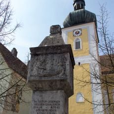
St. Georg
223 m
Cultural heritage D-3-6335-0046 in Königstein (Oberpfalz)
227 m
Kriegerdenkmal
213 m
Sackdillinger-Krottenseer Forst
1.1 km
Gasthof zum Hirschen
204 m
Ackerbürgerhaus
239 m
Ackerbürgerhaus
361 m
Ehemals zum Schloss gehöriges Wohnhaus mit Fachwerkgiebel
233 m
Mansarddachbau
244 m
Cultural heritage D-3-6335-0047 in Königstein (Oberpfalz)
236 m
Cultural heritage D-3-6335-0029 in Königstein (Oberpfalz)
1 km
Schulhaus
243 m
Ackerbürgerhaus
310 m
Traufseitbau
216 m
Thorstein E von Königstein
661 m
Ackerbürgerhaus
252 m
Scheune Oberer Markt 24; Oberer Markt 30 in Königstein (Oberpfalz)
27 m
Walmdachbau Schloßgasse 6
263 m
Altes Rathaus
213 m
Wohnhaus
291 m
Ehemaliges Rotgerberhaus
29 m
Mauer Schloßgasse 5 in Königstein (Oberpfalz)
240 m
Kneippanlage
282 m
Naturbad Königstein
455 m
Königstein-Blick
621 m
Scenic viewpoint
955 m
Scenic viewpoint
1.1 kmReviews
Visited this place? Tap the stars to rate it and share your experience / photos with the community! Try now! You can cancel it anytime.
Discover hidden gems everywhere you go!
From secret cafés to breathtaking viewpoints, skip the crowded tourist spots and find places that match your style. Our app makes it easy with voice search, smart filtering, route optimization, and insider tips from travelers worldwide. Download now for the complete mobile experience.

A unique approach to discovering new places❞
— Le Figaro
All the places worth exploring❞
— France Info
A tailor-made excursion in just a few clicks❞
— 20 Minutes