
Ökonomiebau, mit Ständerbohlen-Konstruktion im Erdgeschoss und Traidkasten im Obergeschoss, 1. Drittel 19. Jahrhundert
Location: Hebertsfelden
Address: Ponhardsberg 7
GPS coordinates: 48.40524,12.83643
Latest update: November 19, 2025 02:41
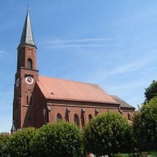
St. Emmeram
1.3 km
St. Jakobus (Rottenstuben)
1.9 km
Katholische Filialkirche St. Koloman
1.9 km
Cultural heritage D-2-7542-0035 in Hebertsfelden
1.3 km
Cultural heritage D-2-7543-0099 in Hebertsfelden
1.9 km
Cultural heritage D-2-7642-0004 in Hebertsfelden
1.5 km
Cultural heritage D-2-7543-0008 in Hebertsfelden
496 m
Cultural heritage D-2-7543-0009 in Hebertsfelden
1.1 km
Stockhaus eines Vierseithofes
1.8 km
Ehem. Pfarrhof
880 m
Friedhofskapelle Kirchenplatz 1 in HebertsfeLenn
1.3 km
Stockhaus mit verschaltem Blockbau-Obergeschoss
1.7 km
Pfarrhaus
1.5 km
Giebelgeteiltes Wohnstallhaus
1.2 km
Traidboden
1.2 km
Remise Höllmühl 1 in HebertsfeLenn
1 km
Einfirsthof
1.9 km
Kornspeicher Gallhub 1 in HebertsfeLenn
1.8 km
Vierseithof
1 km
Wohnstallhaus
1.8 km
Stadel
1.2 km
Backhaus
1.7 km
Wohnhaus
1.2 km
Scheune Gallhub 1 in HebertsfeLenn
1.8 km
Kornspeicher Höllmühl 1 in HebertsfeLenn
985 m
Scheune Höllmühl 1 in HebertsfeLenn
984 m
Wayside shrine, Christianity
1.3 km
Wayside cross
959 mReviews
Visited this place? Tap the stars to rate it and share your experience / photos with the community! Try now! You can cancel it anytime.
Discover hidden gems everywhere you go!
From secret cafés to breathtaking viewpoints, skip the crowded tourist spots and find places that match your style. Our app makes it easy with voice search, smart filtering, route optimization, and insider tips from travelers worldwide. Download now for the complete mobile experience.

A unique approach to discovering new places❞
— Le Figaro
All the places worth exploring❞
— France Info
A tailor-made excursion in just a few clicks❞
— 20 Minutes