
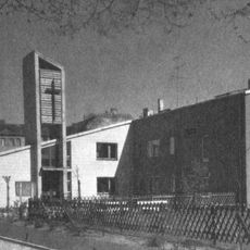
Koloniestraße 57 in Berlin-Gesundbrunnen
Koloniestraße 57 in Berlin-Gesundbrunnen, 1782
Location: Berlin-Mitte
Address: Koloniestraße 57
GPS coordinates: 52.56423,13.38417
Latest update: November 15, 2025 09:07
Martin-Luther-Kirche
495 m
Andersen-Grundschule
347 m
Carl-Kraemer-Grundschule
383 m
Prinzenallee 46a
536 m
Haus Römer
476 m
Mietshaus mit Remise
466 m
Stiel-Eiche Kolonie Panke
99 m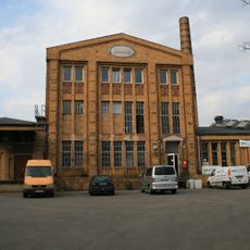
Industriegebäude Kühnemannstraße 51
427 m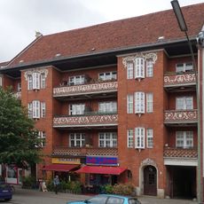
Wohnanlage Wollankstraße 96
537 m
Mietshaus mit Gartenpavillon
444 m
Wohnanlage Brunnenhof in Berlin-Gesundbrunnen
297 m
Koloniestraße 116 in Berlin-Gesundbrunnen
471 m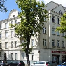
Mietshaus Provinzstraße 113 & 114
464 m
Posadowsky-Häuser
458 m
Produktions- und Hallengebäude Provinzstraße 40-41, 42-42B, 44-44A
497 m
Mietshaus Letteallee 90
510 m
Lifetime
427 m
Work of art
345 m
Work of art
454 m
Mural, Work of art
417 m
Work of art
544 m
Tomb, war grave, military cemetery
359 m
Military cemetery, tomb, war grave
341 m
Grabmal der Familie Karl Friedrich Hensel
526 m
Wandgrabmal der Familie August Hirsch
524 m
Wandgrabmal Familie Gustav Römer
523 m
Wandgrabmal der Familie Paul Hannemann
521 m
Gedenktafel Harald Juhnke
413 mReviews
Visited this place? Tap the stars to rate it and share your experience / photos with the community! Try now! You can cancel it anytime.
Discover hidden gems everywhere you go!
From secret cafés to breathtaking viewpoints, skip the crowded tourist spots and find places that match your style. Our app makes it easy with voice search, smart filtering, route optimization, and insider tips from travelers worldwide. Download now for the complete mobile experience.

A unique approach to discovering new places❞
— Le Figaro
All the places worth exploring❞
— France Info
A tailor-made excursion in just a few clicks❞
— 20 Minutes