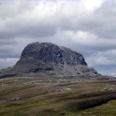
Loftsnut, Berggipfel in Norwegen
Location: Ullensvang Municipality
Elevation above the sea: 1,230 m
GPS coordinates: 60.18940,6.95766
Latest update: November 15, 2025 14:10

Hårteigen
6.2 km
Håvardsvatn
9 km
Tyssevatnet
5.6 km
Einseten
4.2 km
Sandvasshæet
4.6 km
Tresfonn
9.2 km
Børvehallsnuten
7.3 km
Langgrø
10 km
Klokkenuten
6.1 km
Fossane
9.6 km
Solnuten (tumoy sa bukid sa Noruwega, Ullensvang, lat 60,23, long 7,05)
6.6 km
Lok 662 Viersdalen
9.6 km
Bakkanuten
8.4 km
Falkanut
3.9 km
Skålnuten
4.5 km
Rundenuten
10.1 km
Høgahæ
2.7 km
Skitvåknuten
2.3 km
Herrevarden
7.4 km
Sælhæ
6.3 km
Skålnuten
5.2 km
Kinsekvelv
5.2 km
Lok 661 Solheimsdalen
8.3 km
Hærevarden
10.1 km
Oddvyrevarden
8.7 km
Moldkleiv
9 km
Lok 662 Viersdalen
9.6 km
Lok 622, 623, 624, 625 og 626 Reppane
7.3 kmReviews
Visited this place? Tap the stars to rate it and share your experience / photos with the community! Try now! You can cancel it anytime.
Discover hidden gems everywhere you go!
From secret cafés to breathtaking viewpoints, skip the crowded tourist spots and find places that match your style. Our app makes it easy with voice search, smart filtering, route optimization, and insider tips from travelers worldwide. Download now for the complete mobile experience.

A unique approach to discovering new places❞
— Le Figaro
All the places worth exploring❞
— France Info
A tailor-made excursion in just a few clicks❞
— 20 Minutes