Ovdalsdasvarri, protected area in Norway
Location: Tana Municipality
GPS coordinates: 69.96400,26.96800
Latest update: November 22, 2025 04:21
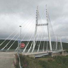
Sami Bridge
6.4 km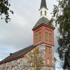
Utsjoki Church
11.3 km
Goržán
3.1 km
Gæđgašguoika
4.3 km
Bađđaguoika
10.5 km
Viercanjearit
8.1 km
Aiteguoika
3.3 km
Borsejohgorži
10.2 km
Gollegoivvut
7.2 km
Luosnjárguoika
8.6 km
Geađggášguoika
4.3 km
Biipogeađgi
4.9 km
Bårsejåkgårŋi
10.2 km
Áitegeađgi
5.7 km
Barn in Utsjoki police station
6.5 km
Kultala
4.5 km
Sauna in Utsjoki police station
6.5 km
Office building in Utsjoki police station
6.5 km
Gonagasgeađgi
5 km
Njuorjjogeađgi
4.2 km
Stable in Utsjoki police station
6.5 km
Seitakivi
7.3 km
Seitakivi
6.9 km
Observation tower, scenic viewpoint, tower
4.3 km
Archaeological site
6.9 km
Geađggášguoika
4.4 km
Borsejohgorži
10.2 km
Báđđaguoika
10.6 kmReviews
Visited this place? Tap the stars to rate it and share your experience / photos with the community! Try now! You can cancel it anytime.
Discover hidden gems everywhere you go!
From secret cafés to breathtaking viewpoints, skip the crowded tourist spots and find places that match your style. Our app makes it easy with voice search, smart filtering, route optimization, and insider tips from travelers worldwide. Download now for the complete mobile experience.

A unique approach to discovering new places❞
— Le Figaro
All the places worth exploring❞
— France Info
A tailor-made excursion in just a few clicks❞
— 20 Minutes