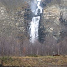
Nokinivat, rapids in Nordreisa, Troms, Norway
Location: Nordreisa Municipality
GPS coordinates: 69.32997,21.95619
Latest update: November 22, 2025 15:34
Reisa National Park
14.5 km
Mollisfossen
6 km
Imofossen
3.7 km
Ráisduottarháldi
22.4 km
Nakabohalos
22.3 km
Imofossen
3.7 km
Sarafossen
22.7 km
Mollešgorŋi
6 km
Liev'lamas
16.5 km
Käyräniva
15.8 km
Ravdoaivi (tumoy sa bukid)
24.1 km
Reisavatnet
22.9 km
Reisavatnet
22.9 km
Scenic viewpoint
3.9 km
Waterfall
20.5 km
Scenic viewpoint
20.9 km
Waterfall
19.2 km
Waterfall
19.4 km
Waterfall
21.9 km
Waterfall
20.5 km
Leamsejavrrit
18.8 km
Waterfall
18.1 km
Imofossen
3.9 km
Mollisfossen
6 km
Mollisfossen - Mollešgorži - Molliskurkkii
6 km
Waterfall
3.9 km
Sarafossen
22.7 km
Sarafossen - Čáragorži - Saarakurkkii
22.7 kmReviews
Visited this place? Tap the stars to rate it and share your experience / photos with the community! Try now! You can cancel it anytime.
Discover hidden gems everywhere you go!
From secret cafés to breathtaking viewpoints, skip the crowded tourist spots and find places that match your style. Our app makes it easy with voice search, smart filtering, route optimization, and insider tips from travelers worldwide. Download now for the complete mobile experience.

A unique approach to discovering new places❞
— Le Figaro
All the places worth exploring❞
— France Info
A tailor-made excursion in just a few clicks❞
— 20 Minutes