Stemnebøskogen, protected area in Norway
Location: Gulen Municipality
GPS coordinates: 60.98800,5.01000
Latest update: November 17, 2025 19:58

Steinkors i Eivindvik
3.6 km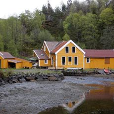
Sellevåg Treskofabrikk
7.5 km
Brossviksåta
9.3 km
Risenes Fortress
7.9 km
Lihellene
5.5 km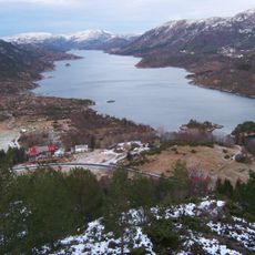
Eidsfjorden
8.2 km
Guleskjeret naturreservat
4.1 km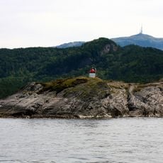
Dingenes Lighthouse
5.2 km
Grima
11.4 km
Kvernøyna
11.1 km
Syllingsvåg fyr
4.9 km
Ramsbarden
12.3 km
Mjåta
11.6 km
Torsholmane
13.7 km
Oddeholmane
12.8 km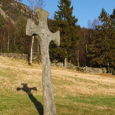
Fetts fk.nr. 3/2 Krossteigen
3.5 km
Fossane
13.3 km
Kvitebergnova
6.2 km
Skolten naturreservat
9.5 km
Vassøyna
5.8 km
Flolid, gbnr 23/3, lok D
6.1 km
Flolid, gbnr 23/2, lok C
6.3 km
Statue, Work of art
6.3 km
Piltevarden
8.3 km
Bufjellet
8.4 km
Kalvafjellet
7.9 km
Slengesolfjellet
11.5 km
Storeggane
11.8 kmReviews
Visited this place? Tap the stars to rate it and share your experience / photos with the community! Try now! You can cancel it anytime.
Discover hidden gems everywhere you go!
From secret cafés to breathtaking viewpoints, skip the crowded tourist spots and find places that match your style. Our app makes it easy with voice search, smart filtering, route optimization, and insider tips from travelers worldwide. Download now for the complete mobile experience.

A unique approach to discovering new places❞
— Le Figaro
All the places worth exploring❞
— France Info
A tailor-made excursion in just a few clicks❞
— 20 Minutes