Nord-Fugløya, protected area in Norway
Location: Karlsøy Municipality
Inception: June 4, 2004
GPS coordinates: 70.26000,20.22000
Latest update: November 22, 2025 13:05
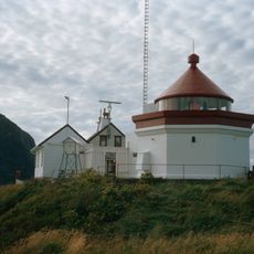
Fugløykalven Lighthouse
6.8 km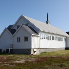
Sengskroken Church
23.9 km
Skipsfjord conservation area
21.4 km
Burøysund bygdemuseum
18.8 km
Brudesløret
24.3 km
Tjuvdalen
23.6 km
Fonnisen
21.5 km
Fugløyskaga
5.7 km
Sandnestinden (tumoy sa bukid sa Noruwega, Troms Fylke, Skjervøy, lat 70,08, long 20,52)
23.2 km
Kirkenestind
23 km
Svarttindflåget
15.9 km
Småtindan
23.8 km
Fossen
22.5 km
Høgtinden
17.1 km
Holbergtinden
16.7 km
Svarttindan
18.8 km
Rødskredet
1.6 km
Rundkallen
880 m
Krykkjeflåget
5.7 km
Vintersetet
24.6 km
Årvik
13.2 km
Stakkeng
21 km
Fugløykallen
1.6 km
Kvalkjeften
18.9 km
Spekkproduksjon
16 km
Fugltinden
1.5 km
Årvik
13.2 km
Lyngnesbukta
22.2 kmReviews
Visited this place? Tap the stars to rate it and share your experience / photos with the community! Try now! You can cancel it anytime.
Discover hidden gems everywhere you go!
From secret cafés to breathtaking viewpoints, skip the crowded tourist spots and find places that match your style. Our app makes it easy with voice search, smart filtering, route optimization, and insider tips from travelers worldwide. Download now for the complete mobile experience.

A unique approach to discovering new places❞
— Le Figaro
All the places worth exploring❞
— France Info
A tailor-made excursion in just a few clicks❞
— 20 Minutes