Lokalitet 35, Felt A, rock art in Sarpsborg, Østfold, Norway
Location: Sarpsborg Municipality
GPS coordinates: 59.21141,11.16679
Latest update: November 21, 2025 02:46

Bustgård
296 m
Busgård II
277 m
Lokalitet 35, Felt B
20 m
Busgård
295 m
Busgård
330 m
Solberg søndre
300 m
Solberg nordre
470 m
Bø
388 m
Solberg søndre
288 m
Solberg Øvre II (Storskipet med kahytt)
451 m
Lokalitet 37, Solvåg
316 m
Solberg nedre XI
454 m
Lokalitet 34, Bustgård III
107 m
Busgård / Solberg søndre
284 m
Lokalitet 59, Bustgård
389 m
Solberg nedre X
443 m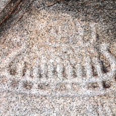
Solberg Søndre II (Solberg nedre II)
431 m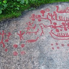
Solberg søndre I (Solberg nedre I)
384 m
Lokalitet 35, Felt E
66 m
Lokalitet 35, Felt F
40 m
Solberg Øvre IV
446 m
Lokalitet 35, Felt C
33 m
Lokalitet 35, Felt D
45 m
Solberg Øvre XX
425 m
Solberg søndre
211 m
Solberg Øvre V
464 m
Busgård
53 m
Solberg søndre
87 mReviews
Visited this place? Tap the stars to rate it and share your experience / photos with the community! Try now! You can cancel it anytime.
Discover hidden gems everywhere you go!
From secret cafés to breathtaking viewpoints, skip the crowded tourist spots and find places that match your style. Our app makes it easy with voice search, smart filtering, route optimization, and insider tips from travelers worldwide. Download now for the complete mobile experience.

A unique approach to discovering new places❞
— Le Figaro
All the places worth exploring❞
— France Info
A tailor-made excursion in just a few clicks❞
— 20 Minutes