Trautgruva
Location: Nord-Odal Municipality
GPS coordinates: 60.47260,11.45809
Latest update: November 12, 2025 16:07
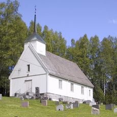
Trautskogen Chapel
5.3 km
Prestberget idrettsanlegg
9.6 km
Trautskogen
1.3 km
Mjøvassfossen
4.7 km
Skuta
2.1 km
Stange
10.1 km
Sandsfossen
10 km
Klingerhaugen naturreservat
10 km
Veslefossen
9.7 km
Engene
5.8 km
Kvernfossen
6.9 km
Styggfallet
5.8 km
Gårdsanlegg
8.8 km
Romsæterberget naturreservat
9.8 km
Sagfallet
7.7 km
Mørkåa
9.9 km
Askholmen, Haugsåa
3 km
Mathisrud
6.7 km
Kiloa
7.4 km
Scenic viewpoint
7.3 km
Sandsfossen
10 km
Mjøvassfossen
4.7 km
Brattfossen
7.7 km
Sagfallet
7.7 km
Veslefossen
9.6 km
Styggfallet
5.8 km
Sandsfossen
10 km
Kvernfossen
6.9 kmReviews
Visited this place? Tap the stars to rate it and share your experience / photos with the community! Try now! You can cancel it anytime.
Discover hidden gems everywhere you go!
From secret cafés to breathtaking viewpoints, skip the crowded tourist spots and find places that match your style. Our app makes it easy with voice search, smart filtering, route optimization, and insider tips from travelers worldwide. Download now for the complete mobile experience.

A unique approach to discovering new places❞
— Le Figaro
All the places worth exploring❞
— France Info
A tailor-made excursion in just a few clicks❞
— 20 Minutes