
Ullstølen
Location: Ullensvang Municipality
GPS coordinates: 59.86981,6.87328
Latest update: June 13, 2024 15:12
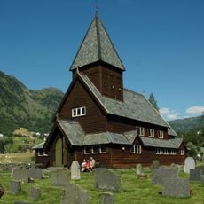
Røldal stave church
5.2 km
Novlefoss
4.4 km
Klentenuten
3.3 km
Tarjebudalen
3.4 km
Novlefoss
4.3 km
Frøystølen
3 km
Grøndalen
4.5 km
Oksastølen
947 m
Austdalen, Røldal
3 km
Grytingstøl
5.3 km
Innihagastølen
2.8 km
Tangavadet
2.9 km
Hagastølen
1.8 km
Nyastøl, Røldal
1.6 km
Ved Votna
6.8 km
Bråstøl
724 m
Tjørna
3.7 km
Ved Gauthellernuten
4.1 km
Øvlandsstølen
611 m
Merkestein
590 m
Einungsstølen
369 m
Grøvesstølen
4.7 km
Einungsstølen
369 m
Prosjekt Nordmannsslepene - Markedsplass, Røldal
5.3 km
Bergsstølen
2.5 km
Fjellsjå
5.9 km
Valldalen
6.1 km
Scenic viewpoint
6.2 kmReviews
Visited this place? Tap the stars to rate it and share your experience / photos with the community! Try now! You can cancel it anytime.
Discover hidden gems everywhere you go!
From secret cafés to breathtaking viewpoints, skip the crowded tourist spots and find places that match your style. Our app makes it easy with voice search, smart filtering, route optimization, and insider tips from travelers worldwide. Download now for the complete mobile experience.

A unique approach to discovering new places❞
— Le Figaro
All the places worth exploring❞
— France Info
A tailor-made excursion in just a few clicks❞
— 20 Minutes