Sakrisøy, protected area in Norway
Location: Hyllestad Municipality
Inception: December 20, 1991
GPS coordinates: 61.22800,4.97200
Latest update: November 14, 2025 23:48
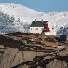
Geita Lighthouse
9.8 km
Hersvik Church
7.5 km
Krakksfjellet
3.4 km
Ramsholmen
4.5 km
Bunesholmane
8.5 km
Krokholmen
9.8 km
Ønaholmane
11.3 km
Engevik
8.7 km
Skardholmen
11.2 km
Kvitingane
9.2 km
Raudøy
8.9 km
Fossen
9.5 km
Leirvåg 6
10.4 km
Høgeheia
10.1 km
Myrbærskjera
6.8 km
Fetts fk.nr. 1/1-4
10.1 km
Storefossen
6.8 km
Fetts fk.nr. 1
3 km
Leirvåg 1 (Fetts fk.nr. 1/2)
10.4 km
Leirvåg 4 (Fetts fk.nr. 2/2 Leirvågneset)
10.5 km
Leirvåg 2 (Fetts fk.nr. 1/1 Ytste Naustvikja)
10.4 km
Fetts fk.nr. 2/1 Leirvågneset
10.5 km
Leirvåg 5 (Fetts fk.nr. 6/2 og 7)
10.4 km
Lammetun kystfort
5 km
Sandvika
9.6 km
Teigesåta
9.8 km
Fossen
9.5 km
Storefossen
6.9 kmReviews
Visited this place? Tap the stars to rate it and share your experience / photos with the community! Try now! You can cancel it anytime.
Discover hidden gems everywhere you go!
From secret cafés to breathtaking viewpoints, skip the crowded tourist spots and find places that match your style. Our app makes it easy with voice search, smart filtering, route optimization, and insider tips from travelers worldwide. Download now for the complete mobile experience.

A unique approach to discovering new places❞
— Le Figaro
All the places worth exploring❞
— France Info
A tailor-made excursion in just a few clicks❞
— 20 Minutes