Såta, Berggipfel in Norwegen
Location: Seljord
Elevation above the sea: 1,068 m
GPS coordinates: 59.53957,8.67309
Latest update: November 15, 2025 13:02

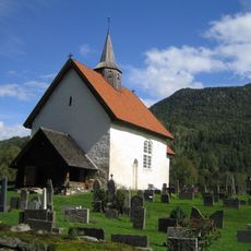
Seljord Church
6.2 km
Vallaråi Bridge
6.3 km
Humleneset
3.1 km
Baklinuten
1.2 km
THO NEDRE
6.9 km
Ambjørndalen
7 km
Heggedalsnuten
4.9 km
Skorvetoppen
5 km
Skotet
5.9 km
Stordokknuten
4.5 km
Fjøllstaulfossane
4.1 km
Gygretrappine
4.7 km
ØVERLAND NORDRE
4.8 km
KOPARVOLLEN SELSTADLOFTET - KOBBERVOLDEN
6.6 km
Åsheim (Aasheim) østre M/Jonsli
6.7 km
SUNDBØ SUDISTOGO
5 km
Seter
2.9 km
Seljord med Taraldskirken
5.9 km
Handkløvsteinen
3.6 km
Seljord Camping
6.1 km
Kikkeskåp
4.8 km
Sprellende ku
6.9 km
Installation artwork, Work of art
6 km
Work of art, sculpture
6.1 km
Scenic viewpoint
5.5 km
Valskarsnuten
5.6 km
Scenic viewpoint
6 km
Optical telescope, telescope, scenic viewpoint
6.1 kmReviews
Visited this place? Tap the stars to rate it and share your experience / photos with the community! Try now! You can cancel it anytime.
Discover hidden gems everywhere you go!
From secret cafés to breathtaking viewpoints, skip the crowded tourist spots and find places that match your style. Our app makes it easy with voice search, smart filtering, route optimization, and insider tips from travelers worldwide. Download now for the complete mobile experience.

A unique approach to discovering new places❞
— Le Figaro
All the places worth exploring❞
— France Info
A tailor-made excursion in just a few clicks❞
— 20 Minutes